
Heatwaves to Hailstorms: Decoding India’s Erratic Weather
India’s weather in early 2026 has swung wildly from scorching heatwaves to sudden thunderstorms and hailstorms, defying seasonal norms. March began with unusual highs across north and west India, only to pivot to cooling rains by mid-month, while IMD forecasts a cooler-than-expected May amid above-normal rainfall risks. This volatility raises urgent questions on climate drivers and future patterns.
Context
March 2026 marked a stark departure from typical pre-monsoon patterns. Early in the month, heatwaves gripped Jammu & Kashmir, Punjab, Himachal Pradesh, Gujarat, and Maharashtra, with temperatures surging 4-6°C above normal—uncommon before peak summer. By the third week, two intense Western Disturbances (WDs) on March 13 and 18 triggered widespread thunderstorms, hailstorms, intense rainfall (over 115 mm in 24 hours in spots), and even snowfall in higher altitudes.
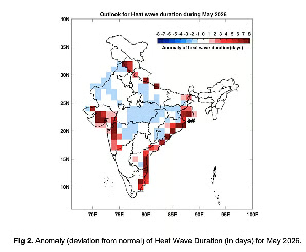
Regions like the western Himalayas, northeast, central India, and parts of the south saw sharp temperature drops, providing relief but disrupting agriculture and daily life. IMD’s May outlook predicts normal to below-normal maximums for many areas due to excess rain (110% of long-period average), though heatwaves persist in Himalayan foothills, east coast, Gujarat, and Maharashtra. Nighttime highs will rise nationwide, signaling ongoing instability. This erratic shift, amid ENSO neutral conditions tilting toward El Niño, underscores broader climate disruptions.
Phenomena
The key culprit: Western Disturbances, extra-tropical storms originating in the Mediterranean, traversing West Asia to hit northwest India. In March 2026, successive WDs interacted with cyclonic circulations and moisture from the Bay of Bengal and Arabian Sea, fueling convection.
This spawned Nor’westers (Kalbaisakhi) in the east—fierce pre-monsoon storms with thunder, lightning, hail, and gusts up to 50 kmph. Heatwaves formed via intense solar heating (land temps >40°C), creating upward air motion that mixed with incoming moisture for towering cumulonimbus clouds producing hail. Geographical spread hit northwest (Punjab heat to rains), northeast (Sikkim hail), central plains, and south (Kerala thunderstorms). May’s overlap of heat and storms stems from persistent WDs amid seasonal transition.
Concept
Western Disturbances are low-pressure systems bringing winter precipitation to northwest India via westerly jet streams. They intensify when coupling with easterly troughs or tropical cyclones, as in March 2026. El Niño Southern Oscillation (ENSO) adds context: neutral now, but warming Pacific waters signal El Niño by May-July, weakening monsoons (IMD forecasts 92% of LPA, below normal).
Heatwaves occur when surface temps exceed 40°C (plains) or 30°C (hills) for two days, driven by high pressure and dry northerlies. Hailstorms form in unstable atmospheres: supercooled water droplets in thunderclouds freeze into hail via updrafts. Climate change amplifies this—warmer air holds more moisture (7% per 1°C rise), boosting extreme swings. Indian Ocean Dipole (IOD) neutrality further modulates patterns.
Analysis
Positive Impacts:
Rainfall from WDs and hail cooled overheated regions, replenishing reservoirs depleted by early heat (e.g., northwest India). It boosted rabi harvests in Punjab-Haryana via timely moisture and controlled pests via cooler temps. May’s predicted above-normal rains (110% LPA) could mitigate drought risks, support kharif sowing, and lower fire incidents in forests. Urban relief from heat reduced health strains temporarily.
Negative Impacts:
Erratic patterns damaged standing crops (wheat, vegetables) via unseasonal hail—losses in Madhya Pradesh and Bihar topped ₹500 crore. Flooding from intense spells hit lowlands, while heatwaves spiked power demand (national peak 220 GW) and heat-related illnesses (over 1,000 cases). Aviation disruptions (200+ flights delayed) and infrastructure strain (power outages) compounded woes. Looming El Niño threatens deficient monsoons, risking food inflation and water scarcity. Northeast vulnerabilities (e.g., Assam landslides) highlight regional inequities.
Government Schemes
India’s response integrates monitoring, resilience, and adaptation. India Meteorological Department (IMD)‘s Mausam app and early warnings via SMS saved lives in March hail events. National Disaster Management Authority (NDMA) guidelines fund crop insurance under Pradhan Mantri Fasal Bima Yojana (PMFBY), covering 5 crore farmers with ₹30,000 crore payouts yearly.
Heat Action Plans (HAPs) in 130+ cities (e.g., Ahmedabad model) mandate cooling centers, water kiosks, and school closures—deployed in Gujarat heatwaves. Jal Jeevan Missionenhances rural water security amid erratic rains, targeting 100% tap coverage by 2026. National Mission for Sustainable Agriculture (NMSA) promotes climate-resilient crops (e.g., drought-tolerant millets). Green India Mission boosts forest cover for microclimate stability. Budget 2026 allocates ₹2 lakh crore for climate resilience, including AI-driven forecasts.
Way Forward
Predictability tops priorities: IMD must scale AI models and Doppler radars (target 100 by 2027) for hyper-local 72-hour forecasts. Integrate private satellite data (e.g., NASA-ISRO ties) for ENSO tracking. Farmer outreach via Kisan Call Centers and apps like Meghdoot can enable agro-advisories, shifting to short-duration varieties.
Urban planning demands green roofs, cool pavements, and HAP expansions to 500 cities. Nationally, enforce Paris Agreement NDCs with ₹50 lakh crore green investments, prioritizing vulnerable Northeast via state climate plans. International collaboration—e.g., WMO El Niño forums—strengthens early alerts. Community-level micro-insurance and watershed management build grassroots resilience. By blending tech, policy, and awareness, India can tame these weather whims into manageable challenges.
You may also like

Fundamental Duties